


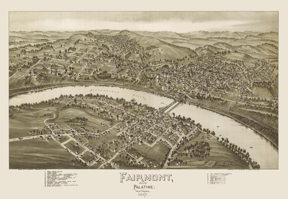
Our Fairmont 1897 wallpaper captures a historic bird's-eye view of Fairmont and Palatine, West Virginia, detailed with 19th-century etching-style charm. The panoramic map illustration outlines rows of period houses, civic buildings, and street layouts along the Monongahela River, framed by rolling hills, clusters of trees, and connecting bridges. Rendered in a warm palette of light brown, sepia, and earthy tones, this design brings a tranquil, nostalgic character to the wall while preserving intricate cartographic details. Like all our wall murals, it is made to measure to fit your exact wall dimensions on PVC-free paper with a subtle physical surface structure.

Wallpaper - Fairmont 1897
Available as
Premium
Our classic, go-anywhere premium paper
- Matte finish
- Paste application
- Easy to install
Popular choice £42/m²
Premium Textured
Our most luxurious paper with a slightly textured surface
- Textured matte finish
- Paste application
- Easy to install
Peel & Stick
Our premium self-adhesive paper with a matte finish
- Matte finish
- Self-adhesive
- Removable and easy to install
Always with Wallism
Won’t fade in sunlight
Non-glare
Eco-friendly and 100% PVC-free
Fire rated Class A
Non-woven material
Product info
Name
Fairmont 1897
Design by
Steve Heap
Type
Mural
Wallism ID (MPN)
R22zWMvlArdj
More like this
Save
£35/
m²
Right now - Save 15% with code WALL15
Enter wallpaper dimensions
Width
cm
Height
cm
Add 7-10 cm of extra margin
 Made in Sweden
  30-day money-back guarantee
  Free shipping
  Ships within 2-5 days
 Wallpaper sample
£3 Printed on our premium wallpaper
  Scaled to show the actual image Free shipping
  Delivery time 6-11 business days
 Loading ....
Loading..
How Wallism works

Choose your design
Pick a design from our collection of wallpaper murals.

Measure your wall
Measure your wall and enter the full width and height to see your price.
We produce and deliver
After a review, we produce your order and ship it within 2-5 days.
Loading ....
Loading..